
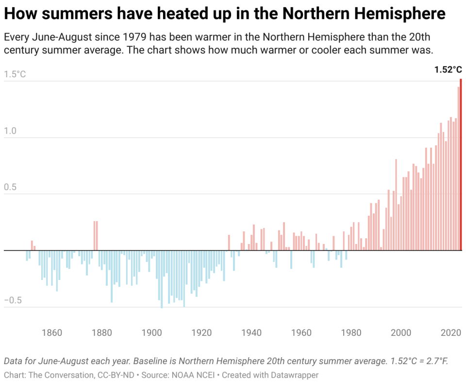
Summer 2024 was officially the Northern Hemisphere’s hottest on record. In the United States, fierce heat waves seemed to hit somewhere almost every day.
Phoenix reached 100 degrees for more than 100 days straight. The 2024 Olympic Games started in the midst of a long-running heat wave in Europe that included the three hottest days on record globally, July 21-23. August was Earth’s hottest month in the National Oceanic and Atmospheric Administration’s 175-year record.
Overall, the global average temperature was 2.74 degrees Fahrenheit (1.52 degrees Celsius) above the 20th-century average.
That might seem small, but temperature increases associated with human-induced climate change do not manifest as small, even increases everywhere on the planet. Rather, they result in more frequent and severe episodes of heat waves, as the world saw in 2024.
The most severe and persistent heat waves are often associated with an atmospheric pattern called a heat dome. As an atmospheric scientist, I study weather patterns and the changing climate. Here’s how heat domes, the jet stream and climate change influence summer heat waves and the record-hot summer of 2024.
What the jet stream has to do with heat domes
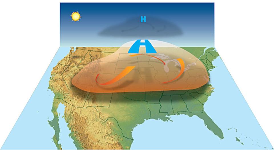
If you listened to weather forecasts during the summer of 2024, you probably heard the term “heat dome” a lot.
A heat dome is a persistent high-pressure system over a large area. A high-pressure system is created by sinking air. As air sinks, it warms up, decreasing relative humidity and leaving sunny weather. The high pressure also serves as a lid that keeps hot air on the surface from rising and dissipating. The resulting heat dome can persist for days or even weeks.
The longer a heat dome lingers, the more heat will build up, creating sweltering conditions for the people on the ground.
How long these heat domes stick around has a lot to do with the jet stream.
The jet stream is a narrow band of strong winds in the upper atmosphere, about 30,000 feet above sea level. It moves from west to east due to the Earth’s rotation. The strong winds are a result of the sharp temperature difference where the warm tropical air meets the cold polar air from the north in the mid-latitudes.
The jet stream does not flow along a straight path. Rather, it meanders to the north and south in a wavy pattern. These giant meanders are known as the Rossby waves, and they have a major influence on weather.
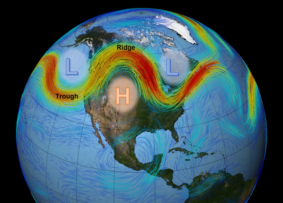
Where the jet stream arcs northward, forming a ridge, it creates a high-pressure system south of the wave. Where the jet stream dips southward, forming a trough, it creates a low-pressure system north of the jet stream. A low-pressure system contains rising air in the center, which cools and tends to generate precipitation and storms.
Most of our weather is modulated by the position and characteristics of the jet stream.
How climate change affects the jet stream
The jet stream, or any wind, is the result of differences in surface temperature.
In simple terms, warm air rises, creating low pressure, and cold air sinks, creating high pressure. Wind is the movement of the air from high to low pressure. Greater differences in temperature produce stronger winds.
For the Earth as a whole, warm air rises near the equator, and cold air sinks near the poles. The temperature difference between the equator and the pole determines the strength of the jet stream in each hemisphere.
However, that temperature difference has been changing, particularly in the Northern Hemisphere. The Arctic region has been warming about three times faster than the global average. This phenomenon, known as Arctic amplification, is largely caused by the melting of Arctic sea ice, which allows the exposed dark water to absorb more of the Sun’s radiation and heat up faster.
Because the Arctic is warming faster than the tropics, the temperature difference between the two regions is lessened. And that slows the jet stream.
As the jet stream slows, it tends to meander more, causing bigger waves. The bigger waves create larger high-pressure systems. These can often be blocked by the deep low-pressure systems on both sides, causing the high-pressure system to sit over a large area for a long period of time.

Typically, waves in the jet stream pass through the continental United States in around three to five days. When blocking occurs, however, the high-pressure system could stagnate for days to weeks. This allows the heat to build up underneath, leading to blistering heat waves.
Since the jet stream circles around the globe, stagnating waves could occur in multiple places, leading to simultaneous heat waves at the mid-latitude around the world. That happened in 2024, with long-lasting heat waves in Europe, North America, Central Asia and China.
Jet stream behavior affects winter, too
The same meandering behavior of the jet stream also plays a role in extreme winter weather. That includes the southward intrusion of frigid polar air from the polar vortex and conditions for severe winter storms.
Many of these atmospheric changes, driven by human-caused global warming, have significant impacts on people’s health, property and ecosystems around the world.
This article is republished from The Conversation, a nonprofit, independent news organization bringing you facts and trustworthy analysis to help you make sense of our complex world. It was written by: Shuang-Ye Wu, University of Dayton
Read more:
Shuang-Ye Wu does not work for, consult, own shares in or receive funding from any company or organization that would benefit from this article, and has disclosed no relevant affiliations beyond their academic appointment.